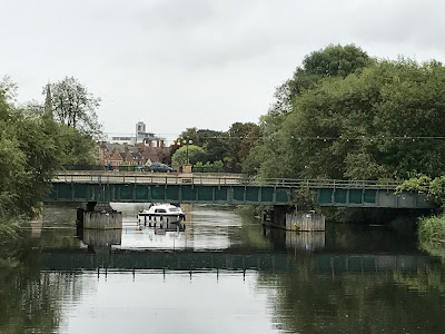
I had always taken it for granted that the practical obstruction to navigation for most boats was the lack of headway under the railway bridges in Bedford. We have not navigated to Bedford but today I spent some time today walking along the river and by chance I was able to see for myself how one of the railway bridges impacts on navigation.
As I walked from the former Britannia Iron Works site, across the new footbridge, a small GRP cruiser approached the Bletchley to Bedford railway line bridge from downstream It decided that it couldn't go any further, turned and moored up by Borough Hall where there are good moorings. This bridge has a nominal air draught of 1.96 m, according to a Bedford Borough Council document. Although the cruiser could have dropped its windscreen, and possibly made it under the bridge, it did look very tight. With the proposed route of the Bedford & Milton Keynes Waterway entering from just upstream of this area, a solution is required for this and the St Pancras line bridge which is only a few metres upstream and only a little higher.
Cruiser chooses not to risk it under a rail bridge at Bedford

1 comments:
There's a more detailed map of the proposed Bedford and Milton Keynes Waterway with is free to download from Waterway Routes at https://www.waterwayroutes.co.uk/wr/maps-bmk.html
The practical limit of navigation for a narrowboat is approximately 3.2km (2 miles) above the railway bridge. That's about one boat length short of the low bridge on the map mentioned above. The water depth decreases to around 0.5m (18 inches) at that point at summer water levels.
Our Waterway Routes narrowboat has been that far twice, the latest being on 12th July 2017.
Post a Comment